
Lake Tanganyika Basin
Communities in the Lake Tanganyika Basin are increasingly affected by flooding, landslides, and environmental degradation caused by climate change, resulting in natural resource scarcity, damages to industrial facilities and public infrastructure and chronic displacement that have a profound impact on people’s livelihoods.
Climate and displacement in the cluster
Communities in the Lake Tanganyika Basin are increasingly affected by flooding, landslides, and environmental degradation caused by climate change, resulting in natural resource scarcity, damages to industrial facilities and public infrastructure and chronic displacement that have a profound impact on people’s livelihoods. Climate projections in the region give cause for concern, as they show that disasters will only increase in terms of their severity and frequency, meanwhile duty-bearers already struggle to cope with the negative impacts of climate change today, let alone prepare for future scenarios.
Over 10 million people live in the Lake Tanganyika Basin. Most of them rely on fisheries, small scale trade and subsistence agriculture for food security and livelihoods, and are, therefore, particularly vulnerable to the impacts of climate change. In 2024, the water level of Lake Tanganyika has already risen to 776.72 meters above sea level compared to the historical average of 772.7 meters, and regional climate projections caution against increasingly severe and frequent climate-induced disasters. This situation is further exacerbated through unsustainable land management and deforestation, which increases soil erosion, sedimentation, and biodiversity loss. Struggling to adapt to increased resource scarcity in the basin, many people are left without a stable income. Populations living in on the lake shore are exposed to repeated displacement.
Read the full cluster context
According to IOM’s Displacement Tracking Matrix (DTM) in the DRC, more than 20,000 individuals have been displaced because of the rising water of Lake Tanganyika in May 2024 only. Already living under the pressure of environmental degradation, climate change further increases the vulnerability of about 120 million people across the Congo Basin, who depend on rain-fed agriculture and basin resources for their livelihoods. Furthermore, climate change exacerbates power dynamics and structures that serve to reinforce social and gendered inequalities. Specifically, women, children, the elderly, and disabled, are disproportionately affected by the impacts of climate change due to unequal access to livelihood services, productive assets, restrictive cultural norms and limited involvement in communal decision-making processes.
Since the turn of the 21st century, countries in the region like the DRC have been frequently portrayed in the international media as “the worst place in the world to be a woman”. Yet the moral and political economy of gender relations across the region has nevertheless been shaped by a long, multitudinous history of women’s experiences of agency and disempowerment, competition and solidarity, whose complexity cannot be captured through victimizing narratives. Despite limited room for maneuvering, women across the region never restricted themselves to the roles imposed on them, with several national and regional examples of emancipation and paths of mobilization. Throughout its implementation, RE2CLID will look at traditional culture and ways to support gender-transformative access to, and distribution of, natural resources and livelihoods and address the power relationships between women and others in the communities where it will intervene.
Seeking alternative means to sustain themselves, hundreds of thousands of people across the region have already migrated to urban areas or joined groups associated with armed conflict or illegal mining. DTM figures show a similarly alarming trend in Burundi, with nearly 90% of the country’s internal displacement due to climate-related disasters, including floods, torrential rains, landslides, storms and hail.
Lake bordering regions of the United Republic of Tanzania have hosted Burundian and DRC refugees and economic migrants for years. Kigoma region, in particular, has been hosting young migrants, agro-pastoralist and nomadic groups for decades. It is also increasingly welcoming people who migrate as a result of a combination of economic, climatic, and demographic factors from other regions in the country as well as from the Kigoma region itself. At the same time, the communities themselves experience internal displacement as soil loss, flooding, erosion, and droughts adversely affect agricultural production, livelihoods, and well-being. While these mobility patterns are centuries old and can play an important adaptation role for populations responding to environmental degradation and climate change, tensions between pastoralists and farmers are increasing as grazing lands are becoming degraded and water is becoming scarcer with progressive climate change. Meanwhile, land-use change and urbanization further restrict the amount of space available for traditional livelihoods.
In general, the negative impacts of climate change in the region are compounded by existing inequalities, high dependency on agriculture and ecosystems services, unsustainable land-use management and spatial planning, as well as local conflicts. Based on a DTM assessment, approximately 96% of IDPs in Eastern DRC, including South Kivu, Tanganyika, North Kivu, and Ituri provinces are displaced due to armed groups and intercommunal conflict. These are frequently related to disputes over natural resource ownership and management, including land, forest, minerals, and water. These vital resources, in turn, are intensely exploited due to the increased needs of local communities and the influx of displaced populations from conflict areas to host communities. In this regard, climate change acts as a risk driver, exacerbating fragilities in existing socio-economic and political dynamics.
Excerpted from the RE2CLID Description of the Action, Cluster 1, section 1.1.
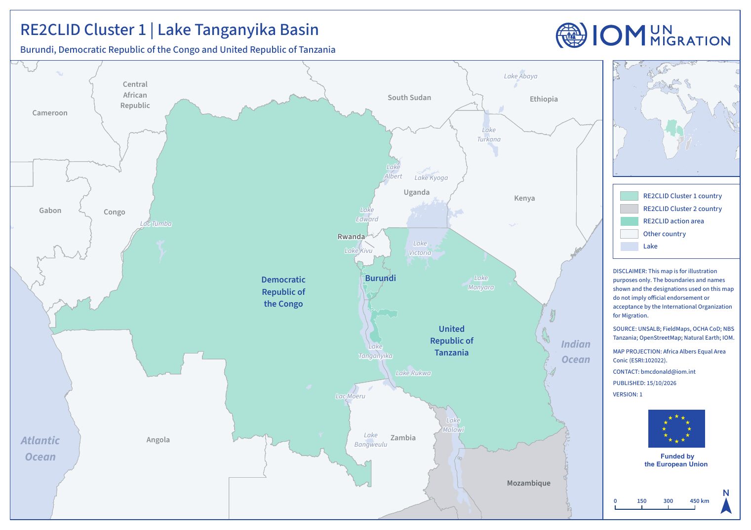
Countries in Cluster 1
Burundi
→Burundi remains one of the least developed countries (ranked 187 out of 191 countries on the Human Development Index in 2022) with a low-income economy.
Democratic Republic of the Congo
→The Democratic Republic of the Congo (DRC) faces intersecting crises, including protracted armed conflict, environmental degradation, extreme poverty, and climate change impacts, making it one of the most complex humanitarian contexts globally.
United Republic of Tanzania
→The Kigoma region, located on the northeastern shores of Lake Tanganyika, hosts a population of approximately 2.3 million and an additional 250,000 refugees from neighboring countries, the majority of whom live in the refugee camps of Nduta and Nyarugusu.
Cluster action areas
Click a district to open its page.
- Action area (admin-1)
- District (admin-2)
Cluster 1 analysis
The cluster CVA consolidates the country analyses into one regional view of multi-hazard displacement risk. It will feed regional policy dialogues and preparedness planning with the Regional Economic Communities, and identify where ecosystem degradation contributes significantly to displacement risk.
Questions the cluster analysis will answer
- What patterns, trends and common vulnerabilities shape displacement across the cluster?
- Where are cross-border hazards and displacement risks concentrated?
- Which regional preparedness, planned-relocation or durable-solutions measures does the evidence support?
Analytical dimensions
- 1Hazard
Sudden-onset (floods, cyclones, landslides) and slow-onset (lake-level rise, drought, degradation) - 2Exposure
People, settlements, infrastructure and livelihoods in hazard-prone areas - 3Vulnerability
Socio-economic sensitivity, disaggregated by sex, age and disability - 4Adaptive capacity
Services, institutions, social protection and coping strategies - 5Displacement risk
Combined likelihood and scale of disaster displacement
Outputs for Cluster 1
- Analysis report · Quarto web pagePending
- Summary brief · PDFPending
- Briefing slides · Quarto Reveal.js slidesPending
Seasonal pressure across the cluster
National and action-area calendars side by side. Open a country page for the full interactive calendar.
| Area | O | N | D | J | F | M | A | M | J | J | A | S |
|---|---|---|---|---|---|---|---|---|---|---|---|---|
| BurundiNational | 3 | 3 | 3 | 2 | 3 | 3 | 2 | 2 | ||||
| Burundi: BujumburaAction area BI2 | 3 | 3 | 3 | 2 | 3 | 3 | 2 | 2 | ||||
| Burundi: BurungaAction area BI3 | 3 | 3 | 3 | 2 | 3 | 3 | 2 | 2 | ||||
| DRCNational | 5 | 5 | 4 | 3 | 2 | 3 | 4 | 2 | 2 | 3 | ||
| TanzaniaNational | 2 | 4 | 4 | 2 | 2 | 2 | 2 | 1 | 1 | |||
| Tanzania: KigomaAction area TZ16 | 2 | 4 | 4 | 2 | 2 | 2 | 2 | 1 | 1 |
Darker cells: more seasonal hazard, lean-season and outbreak events overlap that month. Window Oct 2026 to Sep 2027. Source: ACAPS Seasonal Events Calendar, compiled 21 October 2026.
Disaster Displacement Indicators (DDI)
The Disaster Displacement Indicators, developed by IOM and IDMC, give countries a standard way to collect, report and analyse disaster displacement, so that it can be built into DRR policy and development planning and compared across borders.
In the Lake Tanganyika Basin, RE2CLID will pilot the indicators in at least two Cluster 1 countries. Countries will be selected based on needs identified with national authorities and regional actors, including the Lake Tanganyika Authority, EAC and IGAD/ICPAC. This builds on the pilot already run in Mozambique.
Results will be shared through regional dialogues and will feed the UNDRR–WMO–UNDP Disaster Tracking System and loss-and-damage processes. They will also guide RE2CLID's resilience work under Specific Objective 3.
Regional partners
RE2CLID's regional activities in this cluster are designed with these Regional Economic Communities and regional bodies:
- East African Community (EAC)
- International Conference on the Great Lakes Region (ICGLR)
- Lake Tanganyika Authority (LTA)
- IGAD / ICPAC