
Democratic Republic of the Congo
The Democratic Republic of the Congo (DRC) faces intersecting crises, including protracted armed conflict, environmental degradation, extreme poverty, and climate change impacts, making it one of the most complex humanitarian contexts globally.
Climate displacement in DRC
The Democratic Republic of the Congo (DRC) faces intersecting crises, including protracted armed conflict, environmental degradation, extreme poverty, and climate change impacts, making it one of the most complex humanitarian contexts globally. The country is home to 6.9 million internally displaced persons (IDPs) as of 2024, with displacement primarily driven by violence, instability, and disasters such as flooding, landslides, and prolonged droughts. These events have particularly affected the eastern provinces of North Kivu, South Kivu, and Ituri, which continue to experience recurrent shocks, forcing communities into cycles of displacement.
Climate change is significantly aggravating these challenges by increasing the frequency and intensity of extreme weather events, affecting agricultural productivity and food security. 25.6 million people in DRC are facing acute food insecurity, largely due to a combination of climate stressors and conflict-related disruptions to livelihoods. The increased frequency and intensity of climatic shocks are also leading to displacements around Lake Tanganyika, including in South Kivu, where deforestation on the banks of the lake and rapid urbanization, including the growth of informal settlements linked to the arrival of people fleeing conflict, have increased people’s exposure and vulnerability to floods and landslides. As of April 2025, South Kivu was hosting more than 1.4 million IDPs, including over 100 000 displaced by disaster-related event (IOM, 2025)
Read the full country context
In 2020, several areas of South Kivu were flooded, including the city of Uvira, which triggered 176,000 movements (IDMC, 2024). The large influx of IDPs has further increased the pressure on already limited resources, creating tensions and thus heightened conflict risks with host communities. Previous incidents in South Kivu indicate that such tensions, if unresolved, can result in community clashes. In the Kalehe territory, for example,, floods and landslides in May 2023 killed more than 400 people and displacing thousands in the villages of Nyamukubi and Bushushu. Over a year later, tensions were reported between the displaced and host communities in Kalehe over the use of natural resources (SIPRI, 2024).
Governance weaknesses exacerbate vulnerabilities of populations to disaster risks. Disaster preparedness, disaster response and disaster risk reduction (DRR) and climate adaptation measures remain fragmented and underfunded. Institutional gaps persist including on disaster displacement preparedness and response, leaving local authorities unable to adequately anticipate or manage large population movements. The withdrawal of the United Nations Organization Stabilization Mission in the Democratic Republic of the Congo (MONUSCO) from South Kivu in June 2024 has further strained local governance structures, shifting responsibilities to national and provincial authorities who lack the necessary resources and technical capacity to effectively address instability, environmental challenges and resulting displacement. Despite growing international and national recognition of these issues, policy responses remain insufficient, with no comprehensive framework to address displacement. Development and humanitarian efforts often operate in isolation, with limited integration of conflict sensitivity, climate resilience, and displacement risk reduction into national and local
planning processes. This fragmented response has led to ad hoc interventions rather than sustainable, long-term solutions for displacement-affected communities (DACs). As climate risks intensify, and without coordinated, comprehensive action to reduce vulnerability to disasters and environmental degradation, the humanitarian situation in DRC is likely to worsen—leaving affected populations increasingly exposed to displacement, poverty, and food insecurity.
Excerpted from the RE2CLID Technical Implementation Package: Democratic Republic of the Congo (indicative; may change during inception).
What RE2CLID will do
Disaster forecasts & displacement management
In the DRC, the intervention will focus on strengthening the institutional and operational capacities of disaster risk management actors at national, provincial, territorial, sectorial/chiefdom and community levels on displacement management, particularly along the Lake Tanganyika shoreline. Activities will include strengthening local (sectorial/chiefdom and community level) and provincial capacities to better prepare for, respond to, and address disaster displacement situations. All capacity building activities will be based on needs and capacity assessments conducted at the beginning of the project to ensure an approach that builds on previous interventions and is tailored to local needs. Displacement-sensitive disaster preparedness and response mechanisms will be institutionalized at the community, sectorial/chiefdom and provincial levels, including strengthened coordination capacities and the integration of human mobility considerations into local preparedness mechanisms, including early warning systems (EWS). The action will also contribute to strengthening the quality and availability of displacement data, to strengthen informed risk planning, including through the operationalization and expansion of provincial, sectorial/chiefdom and community EWS. The development of multi-hazard displacement risk assessments will be supported and tailored to the environmental and conflict dynamics of the Rusizi Plain and Lake Tanganyika basin. Partnerships with key institutions including the civil protection, METTELSAT, the Centre de Recherche en Hydraulique (CRH), and the Lake Tanganyika Authority will ensure that interventions are contextually relevant and regionally coherent.
Natural resource governance
In DRC, the design and implementation of natural resource management mechanisms will be reinforced. The involvement of displacement-affected communities and the most vulnerable populations will not only make these mechanisms more inclusive but also more sustainable and effective in mitigating the risks of climate-related displacement. The economic empowerment of DACs through sustainable resource management will be promoted, including gender-responsive support for the livelihoods of women and marginalized groups. The Action aims to leverage the circular economy to stimulate the development of off-farm income-generating activities within DACs, particularly in areas hosting large numbers of displaced people and/or where natural resources are under significant pressure. Finally, the capacities of public administration and local actors will be strengthened to effectively address displacement, sustainable resource management, and climate adaptation. Coordination mechanisms at sub-national levels will be reinforced to ensure an integrated, inclusive, and gender-responsive approach to these challenges.
Resilience & self-reliance
To enhance resilience in high-risk zones such as coastal Lake Tanganyika, the action will promote durable solutions for displacement affected communities. Activities will include support to climate-smart livelihoods and job opportunities, restoration of essential public infrastructure, restoration of natural resources through nature-based solutions and access to basic social services, including social protection and legal identity. The action will also contribute to supporting provincial, territorial and sectorial/chiefdom governance structures in implementing provincial and national durable solutions strategies. Activities will ensure that communities will be empowered to engage in community-based planning processes and community executed operations that contribute to durable solutions and strengthen community resilience to climatic shocks while improving their own livelihoods. Partnerships with local CSOs and decentralized authorities combined with constant involvement of grassroot communities in the implementation process will ensure ownership and sustainability, particularly as MONUSCO’s drawdown has placed greater responsibility on national and provincial structures to manage displacement-related risks and recovery needs.
Location selection
In alignment with the recommendations of the Regional Responses to Climate Displacement (RE2CLID) Final Report, October 2024 (the Final report), the Action plans to target South Kivu Province. South Kivu province, including a focus on strengthening capacities of local authorities and communities in Uvira municipality were proposed as the main target area in the Report. In 2025 the expansion of the M23 armed group to the northern part of the province, including the provincial capital Bukavu in February 2025 and the relocation of the provincial government to Uvira town in March 2025 have impacted provincial and local governance as well as accessibility on some areas, with on-going hostilities that continues to be reported. Considering uncertainties over the situation, flexibility is required to adjust to the conditions on the ground. The need to adjust timelines and potentially initiate activities in neighboring provinces, including Tanganyika province, should be considered during the inception phase of the programme, may the situation in South Kivu remain challenging.
The specific intervention sites will be jointly agreed upon by the EUD and IOM during the inception phase.
District profile summary
Districts (admin-2) in the RE2CLID action areas, with the seasonal hazards and peak-pressure months from their action-area calendar. CVA results will be added as each district analysis is completed.
| District | Admin-1 | Action units | Seasonal hazards & outbreaks | Peak pressure | CVA |
|---|---|---|---|---|---|
| UviraTIP-named · to confirm | Sud-Kivu | District-wide | Rainy season | Oct, Nov, Dec | Pending |
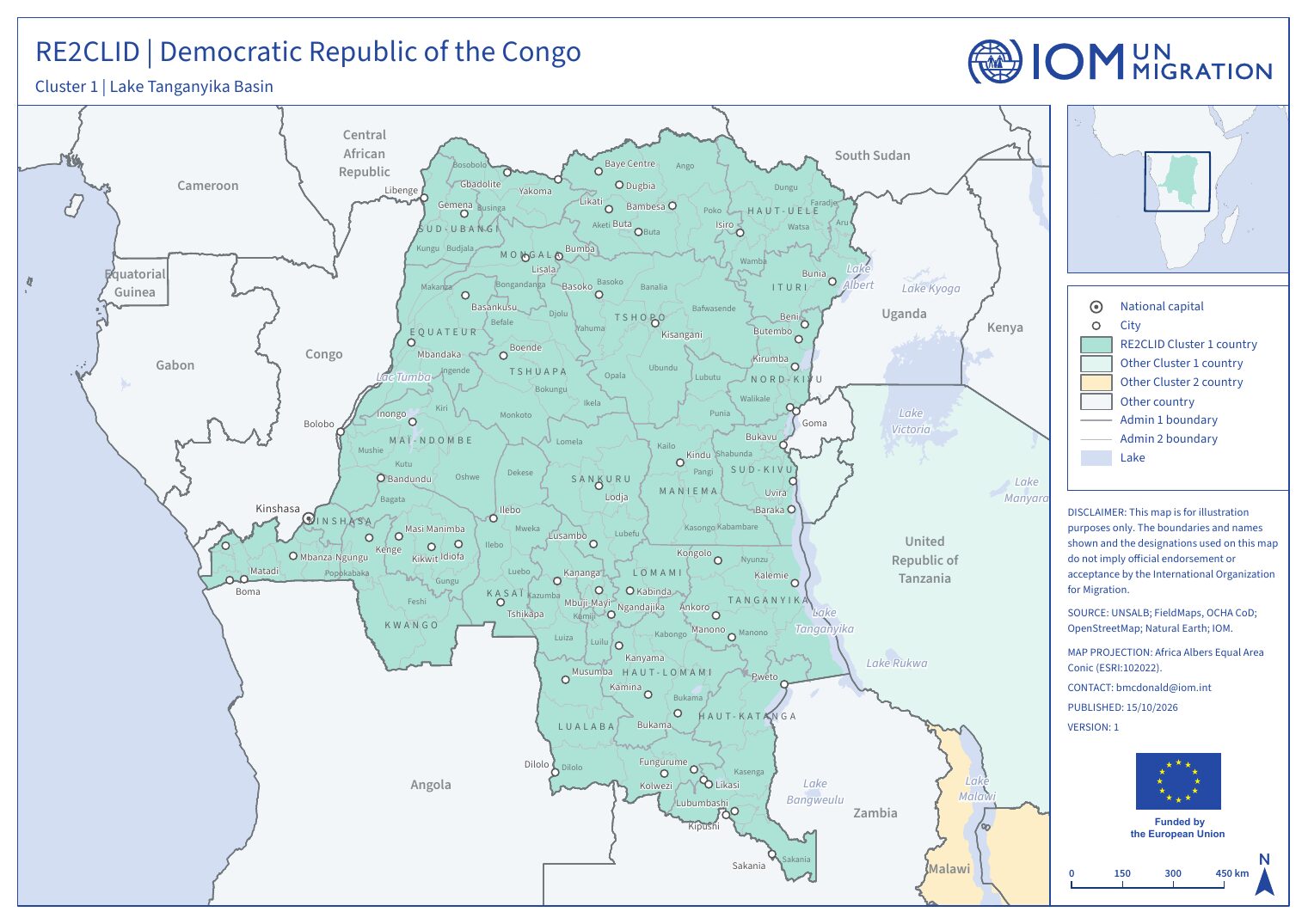
DRC action areas
Seasonal calendar
Recurring seasonal hazards, agricultural seasons, lean periods and outbreaks. Switch between the national calendar and each action area, and use the chips to filter categories.
Today. Events are recurring seasonal patterns, not forecasts.
Calendar narrative & sources
ACAPS lists 35 seasonal events for Democratic Republic of the Congo, 35 of them limited to specific admin-1 areas (shown in brackets).
The recorded seasonal hazards are the rainy season in Nord-Kivu, Ituri (Sep–Dec), the rainy season in Sud-Kivu, Maniema (Sep–Jan), the rainy season in Haut-Katanga, Lualaba, Tanganyika (Sep–Dec), the rainy season in Haut-Katanga, Lualaba, Tanganyika (Jan–Apr), the rainy season in Nord-Kivu, Ituri (Mar–Jun) and the rainy season in Sud-Kivu, Maniema (Apr–Jun). Planting and growing periods: Main planting – Maize in Maniema, Sankuru (Jul–Oct), Main planting – Maize in Lualaba, Haut-Lomami, Haut-Katanga, Lomami (Sep–Oct), 2nd planting – Maize in Maniema, Sankuru (Nov–Jan), Main planting – Maize in Lualaba, Haut-Lomami, Haut-Katanga (Nov–Dec), Main planting – Rice in Lualaba, Haut-Lomami, Haut-Katanga, Lomami (Dec–Jan), 2nd planting – Maize in Lualaba, Haut-Lomami, Haut-Katanga, Lomami (Jan–Feb), 2nd planting – Maize in Bas-Uélé, Tshopo, Haut-Uélé (Feb–Mar), Main planting – Maize in Bas-Uélé, Tshopo, Haut-Uélé (Jun–Jul) and Main planting – Rice in Bas-Uélé, Tshopo, Haut-Uélé (Jul–Aug). Harvests: the main harvest – Maize in Bas-Uélé, Tshopo, Haut-Uélé (Oct–Nov), the main harvest – Cassava in Nord-Kivu, Ituri (year-round), the main harvest – Cassava in Sud-Kivu, Maniema (year-round), the main harvest – Cassava in Haut-Katanga, Lualaba, Tanganyika (year-round), the main harvest – Maize in Maniema, Sankuru (Nov–Jan), the main harvest – Rice in Bas-Uélé, Tshopo, Haut-Uélé (Nov), the main harvest – Maize in Lualaba, Haut-Lomami, Haut-Katanga, Lomami (Jan–Feb), the main harvest – Maize/Beans/Groundnuts /Rice in Nord-Kivu, Ituri (Jan–Feb), the main harvest – Maize/Groundnuts /Beans/Rice in Sud-Kivu, Maniema (Jan–Feb), the 2nd harvest – Maize in Maniema, Sankuru (Mar–May), the main harvest – Maize in Lualaba, Haut-Lomami, Haut-Katanga (Mar–May), the main harvest in Haut-Katanga, Lualaba, Tanganyika (Mar–Jun), the 2nd harvest – Maize in Lualaba, Haut-Lomami, Haut-Katanga, Lomami (May–Jun), the main harvest – Rice in Lualaba, Haut-Lomami, Haut-Katanga, Lomami (May), the 2nd harvest – Maize in Bas-Uélé, Tshopo, Haut-Uélé (Jun–Jul), the 2nd harvest – Maize/Beans/Groundnuts in Nord-Kivu, Ituri (Jun–Jul) and the 2nd harvest – Maize/Groundnuts /Beans in Sud-Kivu, Maniema (Jul–Aug). The lean season runs from October to November in Nord-Kivu, Ituri, from October to December in Sud-Kivu, Maniema and from January to April in Haut-Katanga, Lualaba, Tanganyika.
The 35 records come from 2 sources dated 2016 to 2023.
- FEWS NET (2016-12-01), via ACAPS Seasonal Events Calendar. fews.net/southern-africa/democratic-republic-congo/food-secu
- USDA (2023-02-08), via ACAPS Seasonal Events Calendar. ipad.fas.usda.gov/countrysummary/Default.aspx?id=CG
DRC country analysis
The country CVA applies the common methodology with national data and partners. It runs multi-hazard displacement vulnerability and risk assessments, and its results feed into risk-informed preparedness, DRR and adaptation planning at national and sub-national levels.
Questions the country analysis will answer
- Which districts and communities are most exposed to the main seasonal and sudden-onset hazards?
- How do socio-economic vulnerability and adaptive capacity differ between action areas?
- How can results be built into national DRM, early warning and anticipatory action systems?
Analytical dimensions
- 1Hazard
Sudden-onset (floods, cyclones, landslides) and slow-onset (lake-level rise, drought, degradation) - 2Exposure
People, settlements, infrastructure and livelihoods in hazard-prone areas - 3Vulnerability
Socio-economic sensitivity, disaggregated by sex, age and disability - 4Adaptive capacity
Services, institutions, social protection and coping strategies - 5Displacement risk
Combined likelihood and scale of disaster displacement
Outputs for Democratic Republic of the Congo
- Analysis report · Quarto web pagePending
- Summary brief · PDFPending
- Briefing slides · Quarto Reveal.js slidesPending