
United Republic of Tanzania
The Kigoma region, located on the northeastern shores of Lake Tanganyika, hosts a population of approximately 2.3 million and an additional 250,000 refugees from neighboring countries, the majority of whom live in the refugee camps of Nduta and Nyarugusu.
Climate displacement in Tanzania
The population is estimated to double in the next 40 years. Kigoma is a diverse region, featuring forested hills, woodlands, palm-fringed beaches, farmland, open valleys and national reserves which are home to a rich wildlife. Kigoma also plays a key role in economic exchanges and trade, connecting the port with Dar es Salaam, as well as neighbouring Burundi and the Democratic Republic of Congo. Ongoing and future infrastructure investments, including roads, ports, airports and energy projects, will further enhance its importance as the major logistics hub on Lake Tanganyika.
Despite its strategic position, Kigoma remains one of the poorest regions in Tanzania, with a poverty rate of 38% compared to the national average of 30% (2021). Education is a challenge, as 82% of the population has reached primary school, 30% secondary school, and only 2% have attended university (socio economic profile Kigoma 2024, according to Tanzania census 2022). Agriculture sector accounts for the highest (76.0%) share of employed persons followed by private sector (11.9 %) and household activities (8.7 %). In the industry sector agriculture, forestry and fishing share the largest percentage (74,8%), other service activities ranked second with 5.6 percent, followed by ‘wholesale and retail trade, repair of motor vehicles and motorcycles’ industry with 5%. Tourism is a sector with potential as are the infrastructure and construction sector.
Read the full country context
Kigoma Region has long been affected by displacements, particularly due to political instability in neighbouring Burundi and the Democratic Republic of Congo and due to internal immigration from densely populated zones in Tanzania, by tribes like the Wasukuma and Bahima. However, in recent years, climate change and environmental degradation have increasingly contributed to internal displacement, exacerbating existing challenges and tensions in the region, floods being the biggest trigger. Flooding in Kigoma has resulted in significant economic losses of 13-16 million USD annually, with projections indicating a potential tripling of these losses (URT, 2019). In April 2020, severe flooding in the Uvinza district experienced severe flooding, affecting around 2,000 people and destroyed over 250 houses (UNDRR, 2024). The region’s ecosystem and socio-economic fabric are under pressure, with rising lake levels, deforestation, poor water resources management and uncoordinated urbanisation among the most pressing issues.
The region’s population is frequently affected by disaster displacement, primarily due to floods. Rising temperatures, longer dry spells, more intense rainfall and increasing rise of Lake Tanganyika all increase exposure of Tanzanian populations to climate change-related natural hazards. Repeated droughts in the northern part of the Kigoma region, coupled with deforestation due to slash and burn agriculture in forested areas, have prompted increasing numbers of nomadic peoples and herders to migrate towards Lake Tanganyika in search of more extensive and better grazing areas in Kigoma district. Flooding in Kigoma has resulted in significant economic losses of 13-16 million USD annually, with projections indicating a potential tripling of these losses (URT, 2019).
While the exact causes remain uncertain, the Lake Tanganyika has been experiencing, since 2015, a rise in water levels (3 m in 10 years) which has resulted in flooding along the lake’s border, causing destruction of infrastructure and displacement of communities as well as pollution of surface and shallow ground water. Hydrological monitoring, impact assessment and research are starting but remain spread over several uncoordinated organisations. Efforts are increasingly coordinated at the regional level (Lake Tanganyika Authority) but still very centrally managed and not yet translated into a coherent response mechanism at the level of the region of Kigoma. As a result, the Port & Railway Authorities, Kigoma Municipality or Regional administration – depending from the Regional Administration and Local Government under the President’s Office (PO-RALG) – are lacking systematic topographic & hydrometric information, necessary to orient decisions in planning and investments.
The rising lake level has also flooded industrial facilities & infrastructures such as oil tanks, farms, roads and ports leading to surface and shallow ground water pollution. The National Environmental Management Council (NEMC) has inadequate capacity for monitoring and no dedicated mitigation measures are in place. In April 2020, severe flooding in the Uvinza district affected around 2,000 people and destroyed over 250 houses (UNDRR, 2024). More recently, starting in 2024, increasing ground water levels flooded a large agricultural and living zone in the center of Kigoma, Kibirizi. The water is only increasing in level and blocking large access roads and has flooded many houses. Taking into account that extreme weather events are only going to increase, Kigoma will only become more prone to the previously mentioned climate and natural disasters.
Fishing communities living in Kigoma city and certain neighbouring villages all over the coast accessible only by boat, are among the most affected by the rising lake level. Many families living near the banks and multiple activities located on the former banks now submerged, are experiencing forced displacements, loss of income and habitat, accessibility challenges due to submerged roads, land degradation and water exploited on the surface or at shallow depths, pollution risks to land, water and aquatic fauna. Port terminals and oil installations have been shut down because they are submerged in water. Landing sites and fish processing sites are often the first areas that are flooded. New health risks and consequences have not yet been assessed. Reportedly, the extreme floodings of 2024 (caused by the El Niño weather pattern) resulted in an increase in cholera cases in 2024 compared to the annual average. The social roles assigned to women place them at the frontline of climate impacts, as they are typically responsible for securing food, water, and energy for their households.
The migration patterns in Kigoma are often pendular or multi-displacement scenarios, where individuals and families move repeatedly as environmental pressures mount. These shifts blur the lines between "host" and "displaced" populations and can lead to resource-based tensions and conflicts. Fishermen and pastoralists increasingly encroach upon farmland and forests, competing with existing communities for land and water access.
IOM conducted a study on Hazard Risk and Vulnerability Mapping in districts that face climate-related hazards in: Kigoma Municipality, Kigoma District Council, and Uvinza District Council. The study found that flooding is the most severe hazard which affected fishermen, farmers, homeowners, tenants, infrastructure, including the water supply, electricity, and the famous Kibirizi fish market. The assessment identified areas more prone to floods, epidemics, water-related accidents and landslides which were ranked the three topmost among the surveyed councils. Urban development plans, particularly in Kigoma, are outdated and do not include a population management component nor mention of natural hazard exposure.
While Disaster Risk Management (DRM) efforts have started (2024), they remain mainly coordinated at the national level by the Prime Minister’s Office - Disaster Management Department (DMD). The focus of the DRM is currently also on reaction to disasters and not yet on the prediction or prevention of disasters. The action is in line with national strategies and works on aspects identified as priorities, as shown by the establishment of the disaster management department and specific contact person in the region of Kigoma. The project is strongly linked to the national climate change response strategy 2021-2026 and the national disaster management strategy 2022-2027. The national climate change response strategy focuses on strengthening climate resilience, which is strongly linked to the project’s aim to reduce the impact of climate change on the communities to avoid displacement, as well as the focus on sustainable land use and forest conservation which will be key priorities and activities supported by the Action. These two country strategies align well with the existing regional strategies especially the East African Community (EAC) disaster risk reduction and management strategy and contributes to achievement of its objective by emphasizing the need to mainstream DRR into sustainable development to build safer and more resilient communities hence shifting paradigm from reactive disaster management to proactive risk reduction. The disaster strategy focuses on resilience of communities and infrastructure, as well as on the improving the disaster risk governance and the coordination between actors, which will be a key focus of the action, including result 2 of specific objective 2.
Excerpted from the RE2CLID Technical Implementation Package: United Republic of Tanzania (indicative; may change during inception).
What RE2CLID will do
Disaster forecasts & displacement management
Disaster risks such as flooding, droughts, and other climate-related hazards continue to disproportionately affect vulnerable populations in the United Republic of Tanzania, especially women and girls. Limited access to gender-responsive early warning systems and disaster management structures exacerbates the risk of displacement and loss of livelihoods. The country has an extensive legal framework for DRM. The National Disaster Management Strategy (2022–2027) recognizes the needs and vulnerabilities of displaced populations and refugees but lack provisions for managing disaster-related displacement. However, most disaster preparedness and response mechanisms are not adequately tailored to reflect the different needs, roles, and capacities of women and men, which limits the effectiveness and inclusiveness of the disaster risk reduction efforts. This gap leaves a critical area of DRM unaddressed, particularly as displacement risks continue to grow. At the local level, authorities and communities are particularly ill-equipped to manage large-scale displacement events and evacuations. Evacuation plans and emergency shelter infrastructures are insufficient, and there is no established system for conducting regular simulation exercises involving mass evacuations. The project will address these gaps through strengthening the gender-responsive disaster forecasting and management systems at the local, national, and regional levels. This includes integrating gender perspectives into risk assessments, developing inclusive early warning systems that ensure timely and accessible information for all, capacity building to government officials and stakeholders, improved coordination, and the development of robust planning and simulation exercises to strengthen Tanzania's ability to manage disaster displacement effectively.
Natural resource governance
One of the key factors contributing to the vulnerability of communities in the Kigoma region to climate-induced hazards and human displacement is the absence of functional village land-use plans. A well-structured, evidence-based land-use planning process is essential to ensure that human settlements are developed in appropriate locations while flood-prone areas are designated as no-development zones. Updating Kigoma’s land-use and urban planning frameworks is crucial to making them more resilient, data-driven, and responsive to the evolving risks in the region. This process will involve identifying safe locations for new infrastructure and housing, utilizing risk maps generated through multi-hazard assessments, and integrating them into enhanced spatial and strategic planning efforts.
Resilience & self-reliance
IOM plans to enhance disaster response and recovery in Tanzania by integrating Disaster-Affected Communities (DACs) into national and local strategies. IOM will support the advocacy for the integration of these action plans into district economic development and Local Adaptation Plans, emphasizing community-driven priorities to mobilize resources and foster partnerships to enhance community resilience.
Location selection
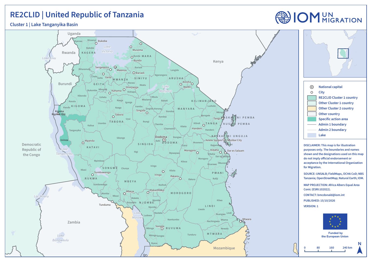
In alignment with recommendations made in the Regional Responses to Climate Displacement (RE2CLID) Final Report, October 2024 (The Final Report) and the IOM Hazard and Risk Vulnerability Mapping, the Action will target the Kigoma District, Kigoma Municipal Council, Uvinza districts and villages and wards prone to flooding due to their close proximity to Lake Tanganyika in Kigoma region. Government authorities at the national level will also participate in capacity interventions to ensure coherence and sustainability of interventions. Specific locations of intervention are to be agreed between the Government of The United Republic of Tanzania, the EUD, ENABEL, and IOM.
District profile summary
Districts (admin-2) in the RE2CLID action areas, with the seasonal hazards and peak-pressure months from their action-area calendar. CVA results will be added as each district analysis is completed.
| District | Admin-1 | Action units | Seasonal hazards & outbreaks | Peak pressure | CVA |
|---|---|---|---|---|---|
| Kigoma District Council TZ160311 | Kigoma | 5 first priority | Rainy season | Nov, Dec | Pending |
| Kigoma Ujiji Municipal Council TZ160323 | Kigoma | 4 first priority | Rainy season | Nov, Dec | Pending |
| Uvinza District Council TZ160411 | Kigoma | 5 first priority | Rainy season | Nov, Dec | Pending |
Tanzania action areas
Click a district to open its profile.
- Action area (admin-1)
- District (admin-2)
Seasonal calendar
Recurring seasonal hazards, agricultural seasons, lean periods and outbreaks. Switch between the national calendar and each action area, and use the chips to filter categories.
Today. Events are recurring seasonal patterns, not forecasts.
Calendar narrative & sources
ACAPS lists 14 seasonal events for Tanzania, 14 of them limited to specific admin-1 areas (shown in brackets).
The recorded seasonal hazards are the rainy season in Arusha, Dar es Salaam +8 (Sep–Dec), the rainy season in Tabora, Rukwa +12 (Nov–Jan), the rainy season in Tabora, Rukwa +12 (Feb–Apr) and the rainy season in Arusha, Dar es Salaam +8 (Mar–May). Planting and growing periods: Main planting in Arusha, Dar es Salaam +8 (Sep–Oct), Main planting – Land preparation in Tabora, Rukwa +12 (Oct–Dec) and 2nd planting in Arusha, Dar es Salaam +8 (Feb–Mar). Harvests: the main harvest – Banana/Cassava in Tabora, Rukwa +12 (year-round), the main harvest in Arusha, Dar es Salaam +8 (Jan–Feb), the green harvest in Tabora, Rukwa +12 (Mar–Apr), the main harvest in Tabora, Rukwa +12 (May–Jul) and the 2nd harvest in Arusha, Dar es Salaam +8 (Jul–Aug). The lean season runs from October to December in Arusha, Dar es Salaam +8 and from November to February in Tabora, Rukwa +12.
The 14 records come from 1 source dated 2017.
- FEWS NET (2017-10-01), via ACAPS Seasonal Events Calendar. fews.net/east-africa/tanzania
Tanzania country analysis
The country CVA applies the common methodology with national data and partners. It runs multi-hazard displacement vulnerability and risk assessments, and its results feed into risk-informed preparedness, DRR and adaptation planning at national and sub-national levels.
Questions the country analysis will answer
- Which districts and communities are most exposed to the main seasonal and sudden-onset hazards?
- How do socio-economic vulnerability and adaptive capacity differ between action areas?
- How can results be built into national DRM, early warning and anticipatory action systems?
Analytical dimensions
- 1Hazard
Sudden-onset (floods, cyclones, landslides) and slow-onset (lake-level rise, drought, degradation) - 2Exposure
People, settlements, infrastructure and livelihoods in hazard-prone areas - 3Vulnerability
Socio-economic sensitivity, disaggregated by sex, age and disability - 4Adaptive capacity
Services, institutions, social protection and coping strategies - 5Displacement risk
Combined likelihood and scale of disaster displacement
Outputs for United Republic of Tanzania
- Analysis report · Quarto web pagePending
- Summary brief · PDFPending
- Briefing slides · Quarto Reveal.js slidesPending